Garmin GPSMAP 67i Handheld GPS and Satellite Messenger Review
The Best All-Around Handheld GPS Satellite Communication Device We've Tested
March 19th, 2024
Home > Gear Reviews > Electronics
Our Verdict
Garmin’s GPSMAP 67i is simply the best all around handheld GPS satellite communication device we’ve tested. Unlike other GPS units that need to be paired with a smartphone to better enhance navigation and make their features more accessible, the 67i is capable of doing everything in one smart self-contained package.
What’s everything? The GPSMAP has a big bright, color screen to view high resolution preloaded and downloaded maps. Using multi-band GNSS satellite technology for rapid and accurate positioning – to within 6 feet – the 67i can track, utilize tracback, use line of sight navigation, and create waypoints and courses. It has location sharing to share trips (by way of the Garmin Explorer app) and can get easily updated weather reports on current conditions and forecasts. It can also message other users, send and receive emails and texts, share data on social media and send an interactive SOS.
The 67i has an altimeter, barometer and compass. Built to tough military standards the 67i works in all kinds of weather and can withstand being submerged for up to 30 minutes in 3 feet of water. The 67i’s internal lithium ion battery provides up to 165 hours of tracking and gets a full charge in as little as 2 hours with a USB-C connection.
There’s even a small flashlight and, if that’s not enough, an app accessible trail encyclopedia, wikiloc.com, that offers global trail information and a worldwide community of other trail users. Whew.
In short, the 67i can do just about everything but your laundry…but it can guide you to the nearest laundromats. Or gas stations, grocery stores or hospitals.
Of note: To utilize all the features of the Garmin GPSMAP 67i, including most importantly the SOS function, you need a subscription. With a subscription, the inReach features –such as mapping, tracking, weather forecasts–are available along with so many other functions in this fully featured satellite communicator. Without a Garmin subscription, the 67i can only be used for GPS navigation, mapping and basic functions.*
*Note: read our important new explainer on Garmin’s new subscription plans and pricing.
Garmin GPSMAP 67i
We create reader-supported, objective, independently-selected gear reviews. This story may contain affiliate links, which help fund our website. When you click on the links to purchase gear, we may get a commission, without costing you an extra cent. Thank you for supporting our work and mission of outdoor coverage for every body! Learn more.
Garmin GPSMAP 67i Specifications

Weight: 8. 7/8 oz
Dimensions: 2.5 x 6.4 x 1.4 inches
Display size: 1.5 inches width x 2.5 inches height by 3 inches: diagonally
Screen pixels: 240 x 400 pixels
Color screen: Chemically strengthened color display screen. Chemically strengthened glass is glass that has been strengthened in a post production process.
Battery life: Rechargeable internal lithium-ion. The 67i has 165 hours with inReach tracking at 10 minute intervals; 189 hours in GPS mode and up to 425 house in Expedition mode with inReach enabled and 840 hours in pure Expedition mode.
Number of routes: This depends on the memory of the device rather than a fixed number. Routes are stored as small GPX files.
OS compatibility: Yes
Satellite messenger: Yes
SOS capable: Yes
Preloaded maps: Yes
Ability to add maps: Yes, the 67i has 16GB of user space for internal memory and that can increased to 32 GB with an addition of a SIM card
Geocaching: Geocache Live
Charging: USB-C
Comparison Table
| DEVICE | MSRP* | WEIGHT (OZ) | SOS | WATERPROOF RATING | BATTERY LIFE |
|---|---|---|---|---|---|
| Garmin inReach GPSMAP 67i | $600 | 8.1 | Yes | MIL-STD-810 | 165 hrs. in 10 min. tracking mode; 425 hrs. in 30 min. mode |
| Garmin inReach Mini 2 | $400 | 3.5 | Yes | IPX7 | 14 days in 10 min tracking; 30 days in 30 min tracking |
| Garmin inReach Messenger | $300 | 4 | Yes | IPX7 | 28 days of battery life in 10-minute tracking mode |
| Garmin inReach GPSMap 66i | 600 | 8.5 | Yes | IPX7 | Up to 35 hours |
| Garmin eTrex 22x | 180 | 5 | No | IPX7 | 25 hrs. in GPS mode |
What We Liked

Attached to the back of a day pack the Garmin GPSMAP 67i displays the onscreen menu for sharing a trip in progress. (Dean Krakel, Special to Treeline Review)
We liked everything about the GPSMAP 67i except the $500 price tag and the nearly 9 oz weight, but this fully featured unit is expensive and weighty for a reason. There’s a lot of features packed into the 67i and its durable, shockproof and weather-proof body. What you get for the price and weight is a device capable of handling any GPS navigation, satellite communications and SOS challenge that you might need.
Although fully capable of pairing with a smartphone for a little more ease of use in messaging, texting, creating routes or courses, the GPSMAP can do all that as a self contained user friendly unit. It does not require being paired with a smartphone to fully utilize its capabilities.
What Could Be Better
It'd be hard to improve on this delightful swiss army of GPS satellite communication units. Because it is capable of doing so much it could be a little overwhelming for a new user. There are so many functions, (25) on the main menu screen and all of those with sub categories of their own.
Even though the 67i is very user friendly it took me a while using it to finally feel comfortable navigating my way around through the various menus.
The biggest improvement would be to make it solar powered like the new Garmin GPS eTrex Solar. For more information on how that battery works, read my in-depth review on the Garmin GPS eTrex Solar.
Additionally the Garmin Messenger can utilize both cellular and satellite networks, using cell towers when available and satellite when not. This would be a handy feature for the 67i to include. For more information, read my in-depth reviews of the Garmin inReach Messenger and the Garmin inReach Messenger Plus.
Target audience and recommended use cases
The 67i is for people who need a rugged GPS/satellite communication device for navigating and mapping courses or routes anywhere in the world with SOS capability in the densest jungles, forests, and deepest canyons.
Even if trekking into the remotest corners of the earth isn’t on your adventure list, the GPSMAP 67i has a lot to offer. The ability to track your travels and share with family and friends, to look at a detailed map and chart a course, to get weather updates, send and receive texts and emails in one device when far afield and be able to send an interactive SOS when needed can benefit anyone who adventures to destinations close or far.
Navigation and Mapping Features

A screenshot of a backcountry trip as it appears on the Garmin Explore app. (Dean Krakel, Special to Treeline Review)
Preloaded maps
The Garmin GPSMAP 67i comes preloaded with highly detailed TopoActive maps of the U.S., Mexico and Canada showing terrain, contours, topographic elevations, mountain summits, parks, coastlines, rivers, lakes.
Ability to add maps
Additional high resolution maps can be obtained with a subscription to Garmin Outdoor Maps+ which has an annual cost of $49.These maps provide enhanced topo maps, satellite imagery, and freshwater features can be downloaded directly to the 67i by Wi-Fi.
Satellite imagery
You can obtain high-resolution satellite maps downloaded with a Outdoor Maps+ subscription.

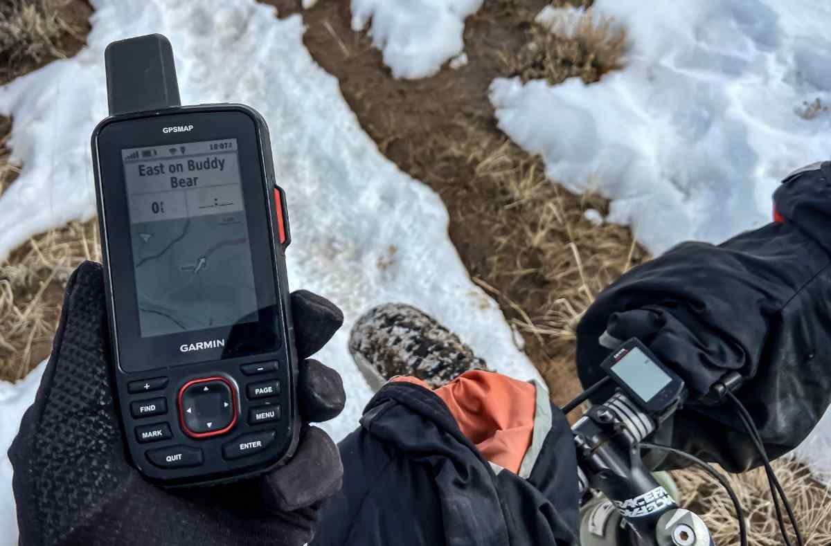
The Garmin GPSMAP 67i has a big, bright, high resolution screen that can display detailed maps to navigate with. The menu button layout on the 67i is well placed and instinctive to use even with gloves. On the left side are "Plus, Find, Mark and Quit" buttons. On the right side are "Minus, Page, Menu and Enter" buttons. The toggle button in the center has four directional buttons, up, down, left, right and are used to navigate through the menu and to move directionally within maps. (Dean Krakel, Special to Treeline Review)
Waypoint and route management
Waypoints and routes are easily created and can be saved for future reference.
Point-to-point navigation
Navigation from point to point can be done by using waypoints. Line of sight navigation is also possible by just pointing the unit at a feature or in a particular direction and moving towards it.
TracBack
TracBack allows you to navigate back to your starting point along the same route you originally took, just in case you need to retrace your route. You can use either the compass or the map.
inReach Interactive SOS
The 67i uses interactive SOS, meaning that once you press the SOS button located under a protective cap on the unit's right side, you will also be able to communicate by text or email with the search and rescue personnel. This is helpful for rescuers because they’ll know the type of rescue needed, how badly injured or lost a user is and other critical details. There’s such an important difference in mobilizing an SAR team for being lost, a twisted ankle, concussion or life threatening injury.

A screenshot of a weather forecast generated by the Garmin GPSMAP 67i, as displayed on the Garmin Explore app. The screen appears just as a weather forecast appears on the screen of the 67i. (Dean Krakel, Special to Treeline Review)
inReach Weather
The 67i comes with the ability to check the weather, both current and forecasted. You have the option of choosing basic, premium or marine, and also for your current GPS location or some place else are easily obtained on the 67i. I never waited over a minute. The conditions were accurate for my location and the forecast was always right on.
Text messages
Text messages, as well as emails, are accessed through iR Messages on the 67i’s main menu screen. Recipients, including multiple recipients can be selected and the message typed on the virtual keyboard.

A screenshot of the Garmin Explorer app from a trip that has shared as seen on Mapshare. When a trip is mapped on the Garmin GPSMAP it goes through the Explorer app and appears on Mapshare. People who receive the link, can with a password, view a user's trip. (Dean Krakel, Special to Treeline Review)
Mapshare
When tracking is initiated the user is asked if they wish to share their trip. A “yes” typed on the main screen of the tracking window will guide the user through a list of options, who receives, how will the trip be shared, through email or text, and then a send button initiates Mapshare.
Livetrack
Through Garmin inReach a 67i user can record their tracking points and transmit them. The tracking will appear on the Garmin Explore and MapShare pages allowing viewers to follow along in real time. Live tracking is initiated when a tracking link is shared by the user with MapShare. The trip automatically appears on the Garmin Explore site as well.
Connectivity

A screenshot of the main menu on the Garmin Explorer app when a smartphone is being utilized by the Garmin GPSMAP 67i. Although the 67i does not need a smartphone connection to do any of its functions the Explore app makes some functions more visible and easier to use. (Dean Krakel, Special to Treeline Review)
Bluetooth
Bluetooth is used for pairing the 67i with a smartphone. Pairing with a smartphone allows you to easily compose and send messages, send an SOS, sync your contact lists, check the weather and send pre-set up check-in messages on the Garmin Messenger and Explore apps.
Cellular and Wi-Fi
The 67i does not offer cellular connection and uses Wi-Fi for data transfer and updates and satellite connectivity through the iridium network for its InReach services, such as two way messaging and SOS. While it can connect to Wi-Fi networks and communicate by satellite it does not connect to cellular networks like a smartphone.
ANT+
The 67i can be paired with wireless sensors using ANT+ technology which allows connection of compatible units like heart rate monitors and enhanced tracking and data collection. When paired with a bluetooth heart rate monitor, the Garmin will monitor your heart rate in real time during your activities.
Sensors

Along with a barometric altimeter and barometer, the Garmin GPSMAP 67i has a 3 axis electronic compass that provides direction even when the user isn't moving. and has tilt correction, meaning that it's able to give a compass reading in any position. The screen is also bright in dimly lit situations such as this. (Dean Krakel, Special to Treeline Review)
Global navigation satellite systems/Multi-band GNSS
The 67i uses multiple Global Navigation Satellite Systems, (GNSS):
GPS
Galileo
QZSS
BeiDou
IRNSS
The sum total of which offer more accurate navigation, positioning, and weather forecasts anywhere in the world, using signals transmitted from these satellites.
Barometric altimeter
The 67i’s barometric altimeter enables the device to measure elevation, ascent, descent and elevation changes.
Barometer
The 67i’s barometer tracks changes in pressure to predict weather changes and determine altitude
Compass
The 67i has a 3 axis electronic compass that provides direction even when the user is stationary. This is different from other Garmin units.
Display and User Interface

When the Garmin GPSMAP 67i is used for messaging this is how the messages appear on the Garmin Explore app. When the Explore app is used the messages appear on the Garmin Messenger app. No smartphone connection is needed to send and receive messages on the Garmin GPSMAP 67i but a smartphone does make viewing and typing easier. (Dean Krakel, Special to Treeline Review)
The 67i’s large display screen and bright resolution makes it easy to navigate through the device’s menu, read and send messages and navigate easily with the onscreen maps. This is a joy after using other small screen GPS devices that need pairing with a smartphone to aid the visuals.
Button layout and ease of use
Menu buttons on the 67i are easy to use and intuitive. There are four buttons located on either side of the main toggle switch. On the left side are “Plus, Find, Mark and Quit” buttons. On the right side are “Minus, Page, Menu and Enter" buttons. The toggle button in the center has four directional buttons, up, down, left, right and are used to navigate through the menu option and also to move directionally within maps.
Visibility in different lighting conditions
The 67i has easy to adjust brightness levels accessible through the main menu in settings. I never had problems seeing the screen in low light, dawn to dusk conditions, nor in bright overhead sunlight or in deep shade. I did have trouble when wearing sunglasses but that’s no different than the screens of other devices or my camera viewfinders.
Battery Life

Stated battery life
According to the Garmin instruction manual the 67i has up to 165 hours with inReach ® enabled with 10 minute tracking. There's up to 180 hours in GPS Mode Up to 425 hours in Expedition mode with inReach enabled Up to 840 hours in Expedition mode.
Real-world battery life
In the real world? I’ve left the 67i powered on in my truck for two weeks in sub freezing temperatures and used it with regular daily tracking use for short hikes, backcountry skis, and fat biking trips, and only had to charge it when it had finally reached quarter strength. Seriously, the 67i has enough juice to last through many days of activity.
Power-saving features
The 67i can utilize power saving by adjustable screen brightness, a battery saver mode and the ability to adjust the GPS settings to less power draining modes.
Durability and Weather Resistance

The author taking a line of sight reading to navigate by in a wintery landscape near Almont, Colorado. The Garmin GPSMAP 67i can operate in cold temperatures down to -4 degrees F. (Dean Krakel, Special to Treeline Review)
Waterproof and shockproof ratings
The 67i is waterproof for 30 minutes when submerged in 3 feet of water. I didn’t personally test this out, but when it accidentally fell off my pack while skiing, it survived being buried in the snow in below zero temperatures for over an hour before I backtracked and found it. No moisture issues.
While Garmin does not specifically rate the 67i for abuse the unit is built to military standards for thermal, shock, and water performance. The device’s body is covered with a sure grip body made of plastic and rubber with chemically strengthened glass.
Performance in extreme temperatures

The 67i performed well in temperatures 20 degrees and colder for extended times, but I had to put it in my coat pocket to stay warm once temperatures exceeded the -4 degrees Fahrenheit minimum temperature operating levels as factory rated. Fortunately the device gives a warning on its menu screen before closing down when it begins freezing to death and is easily revived when placed in a coat pocket.
Although the 67i is rated to work in temperatures as hot as 114 degrees Fahrenheit-ummm no thanks-it’d be best to not leave it in a hot car or in direct sunlight for long periods of time and just like in cooler temperatures, to protect it by keeping it covered or in a pocket.
One feature I found useful is that the 67i, although supposed to be exposed to open sky to reach satellites, will still track through a jacket or shirt pocket, or even the frame bag on a mountain bike which comes in handy in cold weather.
A technician at Garmin explained that the receiving capability on new GPS units is so sensitive that they don’t require being placed in an “open sky” position to operate. While an unobstructed view is optimal, the unit can function, like I said, in a shirt pocket or bike bag.
Geocaching Features
Geocache Live
For geocaching a 67i user will have to go to the geocaching activity on the main menu and follow the screen instructions. A code number will be given and then the user will register the device with https://www.geocaching.com (free). Once registered the site will list nearby geocaches.
User experience for geocachers
I didn’t get a chance to try the 67i in a live geocache hunt, not because I didn’t have faith in the device’s ability but simply because I didn’t want to dig through feet of snow.
Garmin Explore App
The free Garmin Explore App can be downloaded onto a smartphone and allows the phone's larger keyboard and maps to be used for messaging and navigating. While the 67i has a larger screen than the Mini, messages are still easier to read and write and send from a phone. Weather forecasts can be updated, preset messages created, an SOS can be initiated, tracking shared, contacts created and updated.
With the Explore App you can:
Sync data between the Garmin Explore website and the 67i
Create and edit waypoints and routes
Review recorded tracks and activities
Download maps to your mobile device
Organize user data into collections
Access online device support
The beauty is, you don’t have to have a cell phone connection to use the 67i, but you can use a cellphone to enhance certain features and make a few things, like texting and emailing much easier.
Garmin Connect IQ
The 67i can utilize the Garmin Connect IQ app to further customize the device. For instance through Garmin IQ, you can download a Wikilook, through which you can find, share, and download maps of trails all over the world.
Through Wikilook, you can search the world for trails and more information about a trail or area being visited. You can download additional mapping tools, navigation apps and location tracking features. Weather widgets can also be downloaded that provide updates, forecasts and alerts. In addition, other fitness tracking apps and data fields can be added that monitor your performance and health data.


Garmin GPSMAP 66i vs 67i
Improvements
The GPSMAP 67i is the newer version of the GPSMAP 66i.
Here are the improvements:
The 67i has a longer battery life, providing up to 180 hours in tracking in GPS mode and up to 840 hours in expedition mode.
The 66i had 16 hours in GPSmode and about one week in expedition mode.
The 67i uses multi-band technology and has expanded GNSS support which greatly improves location accuracy even in canyons and thick tree cover.
The 67i uses a USB-C connector for charging and connecting to computer ports for uploading maps and downloading data.
The 67i has a more refined, managed, more customizable and easily edited menu.
The 67i offers extended battery life, improved navigation accuracy and a more up to date and commonly found USB-C connection.
Where to buy
The Garmin GPSMAP 67i are popular, so you have options when it comes to retailers. Here are some of the pros of the retailers.
REI
Pros: 100% satisfaction policy for 90 days on electronics; 10% dividend for members.
Other Handhelds to Consider
Garmin eTrex 22x/32x

Weight: 5 oz
SOS: No
Waterproof rating: IPX7
Battery life: 25 hrs. in GPS mode
These units are GPS navigation devices, not fully featured and not in the same class. None of these or the eTrex Solar can send an SOS. We’re talking apples and mangoes here.
Garmin eTrex 22x/32x

Weight: 3.5 oz
SOS: Yes
Waterproof rating: IPX7
Battery life: 14 days in 10 min tracking; 30 days in 30 min tracking
Garmin Mini 2

Weight: 4 oz
SOS: Yes
Waterproof rating: IPX7
Battery life: 28 days of battery life in 10-minute tracking mode
The Garmin Messenger is a simpler satellite unit than the Garmin GPSMap 67i. It’s a fully SOS-capable device that also has two-way messaging and email. By dropping some of the mapping and navigation abilities of other Garmin devices, it’s more affordable and easier to use.
For more information, read my in-depth review of the Garmin Messenger.
Garmin Messenger
Conclusion
Value for money
With a $500-$600 price tag the Garmin GPSMAP 67i is a pricey investment. But, for that investment a 67i user gets a fully featured, rugged, capable of any adventure GPS satellite communicator that does not have to be paired with a smartphone to make its features more usable and accessible. You are only limited by your ability and imagination with a 67i. Chart any course and follow it.
And, in reality, the price isn’t that much more than a Garmin inReach Mini 2, which costs between $400-500 dollars.
Why You Should Trust Us / About the Author
Dean Krakel is a three-time Pulitzer-prize-winning photojournalist, photographer, and photo editor whose work appears in National Geographic, Rolling Stone, Cowboys & Indians, High Country News, National Wildlife, Outside, Time, Yoga Journal, Newsweek, and Life magazines.
With over four decades of experience, his early dramatic documentary-style photographs of the Marlboro Man shot for the Leo Burnett Agency were seen worldwide.
Krakel is the author of three books: Season of the Elk, Downriver, and Krakel’s West. In 2015, Krakel left his newspaper career at the Denver Post to hike the 500-mile long Colorado Trail; a film about that hike—The Long Haul—won a Heartland Emmy Award.
Dean’s fine art prints are valued by collectors and have been exhibited in galleries in Jackson Hole, Wyoming, and Santa Fe, New Mexico. Large exhibition prints of his photographs are on permanent display in the Denver Justice Center. Dean is based in Crested Butte, Colorado.
Instagram: https://www.instagram.com/dkrakel/?hl=en
Twitter: https://twitter.com/dkrakel?lang=en
Websites:


